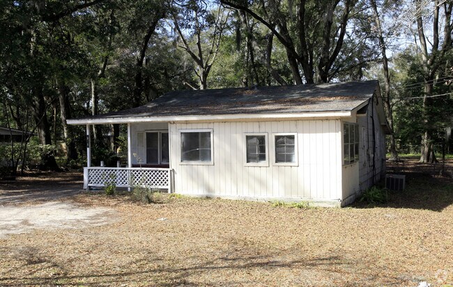
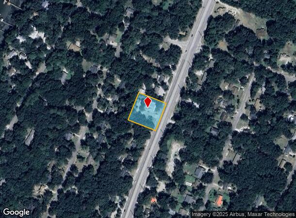
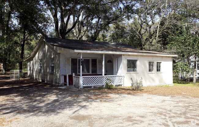
Property Record
91 Sams Point Rd, Beaufort, SC 29907
NEARBY LISTINGS FOR SALE OR LEASE
Property Detail
91 Sams Point Rd
Hilton Head Island-Bluffton-Beaufort, SC
Ladys Is. Suburban & Rural Com
R200-015-000-087E-0000
LOTS 5 6 BLK F BLYTHEWOOD S/D FKA LOT 5 10/01 0.04 AC DEEDED TO R/W DB1461 P1311
Dentalbldg
Beaufort
2025
South Carolina
2024
5-6,10
000902
0.82 AC
3,300 SF
Other Market Areas
DEMOGRAPHICS near 91 Sams Point Rd
1 Mile
3 Mile
5 Mile
2024 Total Population
2,225
14,323
31,986
2029 Population
2,447
15,821
35,328
Pop Growth 2024-2029
+ 9.98%
+ 10.46%
+ 10.45%
Average Age
41
43
43
2024 Total Households
850
6,006
13,514
HH Growth 2024-2029
+ 9.65%
+ 10.02%
+ 10.03%
Median Household Inc
$68,560
$62,253
$64,247
Avg Household Size
2.50
2.30
2.30
2024 Avg HH Vehicles
2.00
2.00
2.00
Median Home Value
$370,899
$339,195
$337,967
Median Year Built
1996
1989
1990
Nearby Places
Map Layers
Map Styles
 Street
 Aerial
- Restaurants
- Banks
- Shops
- Fitness
- Groceries
PUBLIC TRANSPORTATION
AIRPORT
Savannah/Hilton Head International
DRIVE
WALK
Distance
Savannah/Hilton Head International
56 min
49.8 mi
Nearby Properties
Address
Land Use
TOTAL SIZE
Lot Size
Zoning
Address
Land Use
TOTAL SIZE
Lot Size
Zoning
245,864 SF
19.36 AC
6601
Address
Land Use
TOTAL SIZE
Lot Size
Zoning
24,000 SF
4.45 AC
6601
Address
Land Use
TOTAL SIZE
Lot Size
Zoning
19,232 SF
16.27 AC
6612
Address
Land Use
TOTAL SIZE
Lot Size
Zoning
144,673 SF
19.30 AC
4201
Address
Land Use
TOTAL SIZE
Lot Size
Zoning
101,304 SF
6.47 AC
6611
Address
Land Use
TOTAL SIZE
Lot Size
Zoning
34,200 SF
4.18 AC
6601
Address
Land Use
TOTAL SIZE
Lot Size
Zoning
144,226 SF
41.30 AC
6611
Address
Land Use
TOTAL SIZE
Lot Size
Zoning
4,928 SF
4.76 AC
6611
Address
Land Use
TOTAL SIZE
Lot Size
Zoning
16,197 SF
7.50 AC
6611
Address
Land Use
TOTAL SIZE
Lot Size
Zoning
71,309 SF
2.30 AC
6601
Address
Land Use
TOTAL SIZE
Lot Size
Zoning
52,322 SF
6.86 AC
6601
Address
Land Use
TOTAL SIZE
Lot Size
Zoning
75,233 SF
19.91 AC
6612
Address
Land Use
TOTAL SIZE
Lot Size
Zoning
53,862 SF
6.67 AC
9999
Address
Land Use
TOTAL SIZE
Lot Size
Zoning
36,020 SF
3.46 AC
6611
Address
Land Use
TOTAL SIZE
Lot Size
Zoning
58,085 SF
19.97 AC
6612
Address
Land Use
TOTAL SIZE
Lot Size
Zoning
35,734 SF
5.80 AC
6611
Address
Land Use
TOTAL SIZE
Lot Size
Zoning
60,696 SF
0.62 AC
6611
Address
Land Use
TOTAL SIZE
Lot Size
Zoning
41,760 SF
8.75 AC
6612
Address
Land Use
TOTAL SIZE
Lot Size
Zoning
81,955 SF
5.82 AC
4202
Address
Land Use
TOTAL SIZE
Lot Size
Zoning
33,157 SF
0.92 AC
6611
Address
Land Use
TOTAL SIZE
Lot Size
Zoning
1.15 AC
Address
Land Use
TOTAL SIZE
Lot Size
Zoning
4,816 SF
7.92 AC
6611
Address
Land Use
TOTAL SIZE
Lot Size
Zoning
20,250 SF
2.25 AC
Address
Land Use
TOTAL SIZE
Lot Size
Zoning
38,260 SF
10 AC
6611
Address
Land Use
TOTAL SIZE
Lot Size
Zoning
34,800 SF
4.31 AC
6602
Address
Land Use
TOTAL SIZE
Lot Size
Zoning
8.92 AC
6611
Address
Land Use
TOTAL SIZE
Lot Size
Zoning
31,175 SF
2.09 AC
6611
Address
Land Use
TOTAL SIZE
Lot Size
Zoning
50,840 SF
3.78 AC
6611
Address
Land Use
TOTAL SIZE
Lot Size
Zoning
32,324 SF
7.29 AC
6612
Address
Land Use
TOTAL SIZE
Lot Size
Zoning
32,289 SF
1.49 AC
6611
The World's #1 Commercial Real Estate Marketplace
Connect with us
© 2026 CoStar Group
The information above has been obtained from sources believed reliable. While we do not doubt its accuracy we have not verified it and make no guarantee, warranty or representation about it. It is your responsibility to independently confirm its accuracy and completeness. Any projections, opinions, assumptions, or estimates used are for example only and do not represent the current or future performance of the property. The value of this transaction to you depends on tax and other factors which should be evaluated by your tax, financial, and legal advisors. You and your advisors should conduct a careful, independent investigation of the property to determine to your satisfaction the suitability of the property for your needs.